The provision of services to end-users will be one of the most important elements of ODINAFRICA-IV, as it was in ODINAFRICA-III. In ODINAFRICA-IV even more emphasis will be put on providing services to multiple user audiences while identifying the most suitable media and tools to best reach the audiences.
Effective communication is a critical tool for management and research institutions to support applications of science for decision making in oceans and coastal zones. Effective communication benefits NODCs, NCCs, and their partnering organisations in interacting with government and community stakeholders on:
- Priority setting - Identification and prioritisation of problems that stakeholders want institutes to address.
- Participatory approach - Involving stakeholders in a participatory process of addressing environmental issues
- Informed and accountable decision making – Supporting decision making with good science, thereby contributing to greater accountability, efficiency, and transparency of resource allocation for environmental management
- Community ownership – Raising community awareness on prioritised environmental and health related issues through credible science taken-up in media, education, and public forums.
NODCs and partner institutes can benefit from greater exposure and stakeholder interaction, both in terms of reputation as problem solvers and financially through follow-on requests for services – Ultimately this supports the sustainability of institutions and their activities.
In conclusion the different products developed through this work package will utilize different tools, methodologies and media to assure effective communication and maximum audience impact.
Establishment of OceanDataPortal nodes
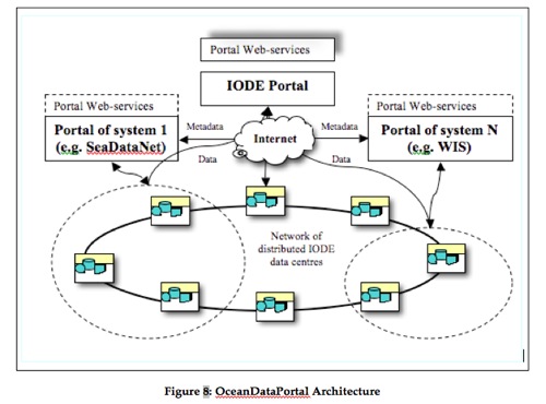
The IODE’s Ocean Data Portal (ODP) will provide seamless access to collections and inventories of marine data from the NODCs in the IODE network and will allow for the discovery, evaluation (through visualisation and metadata review) and access to data via web services. The system architecture will use Web-oriented information technologies to access non-homogeneous and geographically distributed marine data and information. The Ocean Data Portal will deliver a standards-based infrastructure that provides the integration of marine data and information from a network of distributed IODE NODCs as well as the resources from other participating systems, as shown in Figure 8.
The ODP will also be a Data Collection or Production Centre (DCPC) providing data and services to the WMO Information System (WIS). This will link IODE National Oceanographic Data Centres with the National Meteorological and Hydrological Services (NMHS).
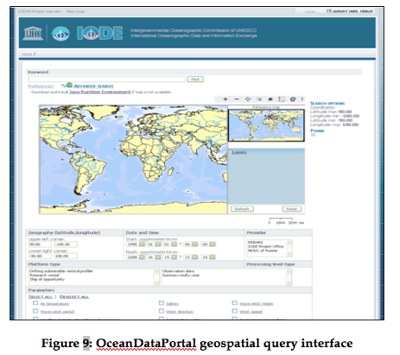
The ODP can be queried in various ways from an easy-to-use Google-like interface to a powerful geospatial query interface (Figure 9).
Within the framework of ODINAFRICA-IV the NODCs will be able to “plug-in” their databases into OceanDataPortal as data providers. NODCs with web-serving capability (and permanent internet connection of sufficient bandwidth) will be able to directly connect to ODP.
NODCs without a permanent internet connection and/or web-server capability will be able to use the central node at the IOC Project Office for IODE and serve their data sets through that facility.
The activities related to ODP will include support for some hardware, software. Training needs will be addressed by WP2.
Metadata Catalogue Service
The importance of metadata to describe marine data has been recognised for some time. Metadata describes data collection methods, instruments, quality control procedures applied, analyses done, location, etc. The Marine Environmental Data Inventory (MEDI) is an inventory of information about marine related datasets that is used within the framework of the IODE system. The aim of the MEDI catalogue is to improve the accessibility to data from multidisciplinary sources that is documented in a standard and consistent way. This is also one of the main goals of the IOC Data and Information Management Strategy.
MEDI-Africa is a regional component of the MEDI catalogue. The MEDI-Africa catalogue will be updated and expanded using a version of GeoNetworkopensource, a standards-based catalogue application designed to manage spatially referenced resources through the internet. The MEDI version of GeoNetwork has been modified specifically for marine data and applies the Marine Community Profile of the ISO 19115 metadata standard. MEDI provides powerful metadata editing and search functions as well as an embedded interactive web map viewer that can enable access to data and services from a variety of sources from ODINAFRICA partners. This will enhance data exchange and sharing between organizations and will provide the community with easy and timely access to available marine data and services to support informed decision making.
ODINAFRICA-IV will provide the ability to author metadata using a standard approach. This metadata will also be used to describe datasets that are found in the African Marine Atlas and will supply an OGC compliant catalogue service that can be harvested by the Oceans Data Portal .
The work package will include support to enable local institutions to establish a local version of MEDI-Africa and to populate the catalogue. Training on how to configure and use the MEDI catalogue will be covered under WP2.
Development of web-based data services
Whereas ODINAFRICA-III has focused on the development of local databases, ODINAFRICA-IV will aim at developing web-based or web-connected database management systems and associate metadata management systems. Development of such services will require training.
Three focused workshops were organised in the last phase to mobilise data on marine molluscs, sponges and decapods. These were included in Marine Species Database for Eastern Africa, which was renamed as the African Register of Marine Species (ARMS) to reflect its expanded geographic scope. An interface will be developed for ARMS to improve access, and national marine biodiversity nodes will be created or strengthened to provide input to the African Register of Marine Species.
The NODCs will be supported to develop web-based services such as direct data extraction from local and international databases into specific formats, online trend generation of data, and plotting and printing of maps and figures from databases.
Development of web-based information services
Already during ODINAFRICA-III considerable work was carried out to develop a number of web-based information services. These included: directory of marine and freshwater professionals (OceanExpert Africa), catalogues of African Marine libraries (AFRILIB), a electronic repository of marine publications and grey literature from Africa (OceanDocs Africa), and an African Ocean Portal. ODINAFRICA-IV will build on these and in particular:
(i) OceanDoc-Africa will be improved with new partners recruited and trained to ensure broader coverage. The development of news services and applications enabling the linkage of publications to related dataset in the NODCs will be explored. Institutional repositories will be also developed to addresses the local needs. These will hold a wide range of materials such as multimedia resources besides scientific publication, posters. Documents and other information sources in danger of being lost will be identified and included in the repositories. These repositories will be a valuable information source for the management and decision making.
(ii) Electronic journals: the development of journal view, already implemented for Egyptian Journal of Aquatic Research (Egypt) Bulletin Scientifique de l’IMROP (Mauritania), Documents Techniques de l’IMROP (Mauritania), Document scientifique/Archives du CRODT (Senegal), Tuna Bulletin (Seychelles), and Bulletin de l’INSTM-Salammbô (Tunisia) will be extended to cover other institutions that produce their own publications.
The directories, library catalogues and other information sources will be updated, maintained and availed online so that they can act as information sources for the portals.
The focus will be on Upgrading/replacement of software, providing open access to scientific output from ODINAFRICA, and coordination and integration of existing tools. Exchange procedures and standards between the different products will be developed to ensure easy access.
Development of national atlases
The African Marine Atlas was a good starting point in the development of a functional Coastal and Marine Spatial Data Infrastructure for Africa. However the scales for the layers in the continental scale atlas are coarse and will not be useful for integrated management of the environment and resources at the local and national levels. The national marine atlas is an important step in making this tool useful.The development of the national atlases will follow a process similar to the African Marine Atlas, with the following steps: (i) setting of protocols and procedures, (ii) data mining, (iii) formatting and conversion of data to shape files, and (iv) atlas compilation. The national atlas cannot be prepared by the NODC alone and will require the participation of a wide range of stakeholder.
Outreach activities and promotional materials
Outreach activities and products will be developed at the national as well as sub-regional and regional level. In this regard we mention again the need to utilize relevant media in accordance with the user audiences. Support under this work package element will include national support for the development of relevant outreach activities (leaflets, brochures, newsletters, web sites, videos, newspaper articles, etc.). It will also include activities related to public awareness including relevant events for school children. The financial support provided is not intended to cover the full cost of the activity.
The data and atlases products that will be developed through Work Package 3 are designed to support the types of stakeholder interactions identified earlier, including priority setting and informed and accountable decision making. Institutes will therefore deliver dissemination materials and activities in this work package that include:
- Visual and interpretive materials such as conceptual diagrams and maps that support understanding of environmental processes and issues, and facilitate stakeholder interactions and decision making
- Policy and media briefs to provide tangible advice for decision making, priority issues and resource deployment
- Outreach and marketing of the project outputs through interaction with stakeholders.
The products developed through Work Package 3 will vary from country to country depending on the priorities identified by NCCs, as will the information disseminated through the national atlases and portals of this work package. Accordingly, NCCs will also identify how these data and information products should be disseminated to support participatory approaches to environmental problem solving in their countries.
Collaboration and co-financing will be sought to undertake the training and development activities for the above outputs. This includes collaborating partners such as the Capacity Development programme of UNESCO/IOC. The second phase of the IOC’s self-driven programme of capacity development in Africa includes supporting marine institutes to market and manage their core business activities, developing these into financial independent and stable centres within the institute and communicating effectively to their stakeholders.
Visual and interpretive materials
Box 1 and 2 in 5.3.2 (Work Package 3) show examples of products and proposed dissemination methods. In the following sections dissemination activities that can be undertaken are shown through the development of potential activity for the proposed product Spatial ocean and coastal resource mapping and scenario products supporting trans-boundary and national decision making (Box 2, 5.2.3: Work Package 3).
Coastal resource mapping can indicate the location and relative loading of point source pollution within an enclosed bay or harbour of interest. Interpretive tools such as the conceptual diagram shown in figure 10, developed for Chesapeake Bay by the University of Maryland, can take this information one step further: showing the interaction with competing interests and the ecological processes that are underway. Stakeholders can use such tools in decision making to reach agreement on the causal relationship of an issue such as a pollution source, and the actions that should be taken to address it.
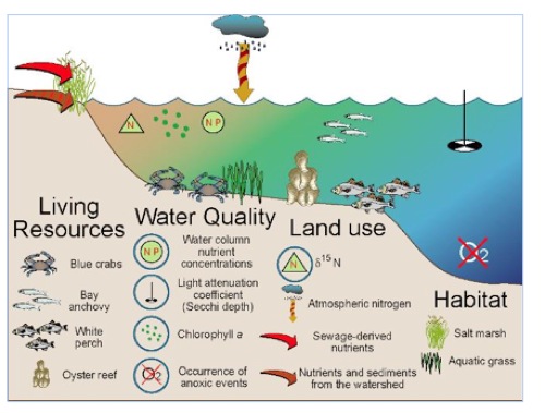
Figure 10: An example of a conceptual diagram, similar to those used successfully in participatory decision making undertaken by the Integrated Applications Network of the University of Maryland ( http://ian.umces.edu
The analysis of data and preparation of products is not sufficient to ensure that the information that has been generated is utilised. Further, the development of visual aids and interpretive products for prioritised issues can assist towards this end, but further effort is still required to support the uptake of this science. To address this ODINAFRICA-IV will support the NODCs and national coordination committees to prepare short documents that convey specific problems and outline possible actions to resolve them (policy briefs). The policy briefs will have to be focused, professional, evidence based, succinct, understandable, and accessible.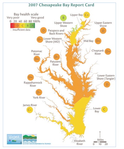
Similarly, materials for the media will be developed that are accessible to the general public and easily taken-up by television, radio and newspapers. In both the development of “briefings” for the media and policy makers, training is required to integrate product outputs into interpreted results and visual aids that speak clearly to the target audience. For the example of decision making on point source pollution and water quality described in the previous section, countries have used report card approaches to clearly speak to stake holders about issues they see relevant.
The Integrated applications Network (IAN) of the University of Maryland (http://ian.umces.edu) has used report cards (Figure 11), and conceptual diagram to support numerous participatory decision making process for the management of coastal and marine resource. IAN participated in the IOC Capacity Development workshop in Maputo, April 2007, presenting to directors of African marine institutes case studies of some of these activities. Directors recognised the opportunity to use such tools and methodologies in their own institutes, welcoming the Capacity Development programme of IOC to further pursue these initiatives in their activities in the region.
Outreach and Marketing
As with media and policy briefs, outreach activities will be tailored to the issues, products and stakeholders addressed by the NCCs. This said NODCs and participating institutions will undertake training and implementation of a number of broad activities to ensure the output of the ODINAFRICA 4 are effectively communicated, and that the services of the NODC are recognized: Elements will include:
- · Support for the marketing and prioritisation of NODC services and products to key policy makers and line ministries.
- · Training and implementation of targeted outreach meetings with decision makers and the media.
- · National open days for the media and decision makers as well as access for the general public, universities and schools. This will be coordinated Africa wide for greater impact.
- · National support for the development of relevant outreach materials to support public awareness raising (leaflets, brochures, newsletters, web sites, etc.).