FUST and IOC
Humans have been attracted to the ocean from time immemorial. Increasingly, people are relocating to coastal areas to make a living. Almost 65% of the world’s population now live on or near the coast, and people in developing countries, in particular, are heavily dependent on the sea for their food. Meanwhile, the exponential increase in human activities is placing mounting pressure on natural resources in coastal areas and the deeper seas adjoining them.
A sensible approach to the sea
Several multilateral organisations play a key coordinating role in ensuring a sustainable future for our oceans' natural resources. UNESCO’s Intergovernmental Oceanographic Commission (IOC) is the main mechanism responsible for coordinating Ocean Sciences. Its remit complements those of other multilateral organisations. UNEP (United Nations Environment Programme) focuses mainly on the land, including coastal areas, while the Food and Agriculture Organisation (FAO) oversees the management of natural resources (including fisheries). One of the IOC’s priorities is to develop guidance for the implementation of Integrated Coastal Area Management (ICAM) and Maritime Spatial Planning (MSP) globally. An important component of this endeavour is developing an efficient data and information network in consultation with local and regional stakeholders. This is the cornerstone of one of the IOC’s major programmes: International Oceanographic Data and Information Exchange (IODE). IODE contributes significantly to the spread of global knowledge about the seas and the Ocean. It also works – in close collaboration with the World Meteorological Organisation (WMO) – to develop international standards and protocols, and safeguards free and open access to ocean data and information. Finally, it provides instruments that support data management for regional and large international programmes, enabling member states to access a global network of databases.
FUST SUPPORT FOR IOC 2019-2023
The main large-scale projects supported by the Government of Flanders in phase V (2019-2023) include:
The OceanTeacher Global Academy-2
FUST funded phase 2 of the OceanTeacher Global Academy (OTGA) project as “Ocean Teacher Global Academy” during the fifth cycle (2019-2023), to develop the project into a self-standing training platform for all IOC programmes. OTGA offers an internet-based training platform to build and boost capacity related to marine research and observations in IOC member states through classroom training, blended learning, and online self-paced courses. The training sessions are coordinated through a worldwide network of 17 regional or specialised training centres affiliated with universities and research institutes in their respective regions. The selection of these training centres was based on applications from Member States and organisations interested in participating at the start of the project.
Ocean InfoHub (IOH)
The OIH project aimed to develop a global network of ocean data and information that is easily accessible and interoperable among international, regional and national users. By creating a digital ocean ecosystem for all stakeholders, information and knowledge are easily accessible and thus aid in sustainable development. Under the fifth round of funding by the government of Flanders through FUST, the IODE office of the IOC/UNESCO guided the construction of the light-weight ODIS to boost data and information sharing and assessment.
The Pacific Islands Marine Bioinvasions Alert Network (PacMAN)
The PacMAN project was a three-year project aimed at bolstering marine biosecurity in Fiji. IPBES global assessment ranks the introduction of invasive species as one of the key drivers of species extinction. Small Islands and Developing States (SIDS) are at high risk. The PacMAN project, funded by FUST, was conducted by IOC to develop a detailed monitoring system for invasive species and a decision-support tool that can help environmental managers and policymakers to enhance marine environmental protection in Fiji. Several partners were involved, including international bodies like the Secretariat of the Pacific Regional Environment Programme (SPREP), the Pacific Community (SPC), and the International Maritime Organization (IMO); academic institutions like the University of the South Pacific (USP) and Flanders Marine Institute (VLIZ); and various scientific programmes, including GOOS Biology & Ecosystems and the global ARMS project at the US Smithsonian Institution. The project created a training package with the OceanTeacher Global Academy to build capacity in marine environmental monitoring of Pacific islands.
eDNA
The Environmental DNA (eDNA) Expeditions in UNESCO World Heritage marine sites was a global citizen-science project (2021–2023) aimed at monitoring biodiversity using eDNA from seawater samples. Funded by UNESCO and Flanders Trust Funds, the project involved local communities in 25 marine sites to collect and process samples under expert guidance. Data were analysed to assess biodiversity and climate change impacts, with standardised methods shared via the Ocean Biodiversity Information System (OBIS). The project fosters public engagement, supports informed decision-making, and contributes to global marine conservation efforts while advancing tools for the early detection of non-indigenous species. It was endorsed by the UN Ocean Decade.
FUST SUPPORT FOR IOC (2014-2018)
During phase IV (2014-2018), the Government of Flanders, through FUST, supported the following 4 large-scale IOC projects
OceanTeacher Global Academy (OTGA)
Southeast Pacific data and information network in support of integrated coastal area management (SPINCAM)
Caribbean Marine Atlas (CMA2)
Development of Information Products and Services for Ocean Assessments (DIPS-4-Ocean Assessments)
FUST SUPPORT FOR IOC (2009-2013)
During phase III (2009-2013), the following projects were supported
Fourth Phase of the Ocean Data and Information Network for Africa (ODINAFRICA-IV) [an IODE project]
OceanTeacher Academy [an IODE project]
Southeast Pacific Data and Information Network in Support to Integrated Coastal Area Management (SPINCAM) [an ICAM project with cooperation from IODE]
Caribbean Marine Atlas (CMA) [an IODE project]
Flanders supports IODE
[based upon article "Flanders Supports the 'S' in UNESCO", WEWIS review, No. 2, October 2007 by Rudy Herman]
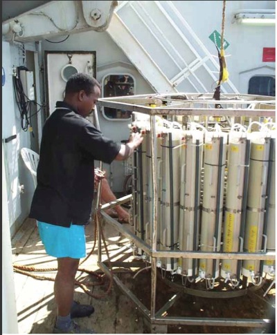
Flanders decided to support the IODE programme through FUST (2003-2007 phase, US$4.15 million, then equivalent to around €3.32 million), focusing particularly on the Ocean Data and Information Network (ODIN). This package of activities promotes close cooperation between two major IOC programmes: Integrated Coastal Area Management and the operational Global Ocean Observing System. When launching the Ocean Data and Information Networks, the UNESCO/IOC Secretariat secured the necessary commitment from all the member states involved with regard to data centre infrastructure and staff. At the same time, the IOC undertook the required capacity building in member states by organising on-the-job training. Flanders’ input in this respect was crucial, not least because the UNESCO/ IOC Project Office for IODE began operating in Ostend in April 2005.
Since this UNESCO expertise centre was established, 15,000 experts from 130 IOC member states have received specialised training. Uniformly trained experts are essential for developing data networks that follow international standards. This on-the-job training led to the rapid development and launch of new ODINS worldwide, based on the successful pilot network ODINAFRICA and its successor ODINCARSA. In total, six ODIN networks have been created and are now operational.
The European SeaDataNet (including the IODE Project Office as a partner), which comprises 49 data centres in 36 countries, works closely with the ODINs. One of IODE’s key tasks is to supply targeted information and products to other IOC programmes. This information and data flow are also streamlined with the activities of other IOC programmes and harmonised with data flows from other organisations such as the WMO and UNEP, resulting in joint activities and products. This can best be illustrated with a few examples.
Obvious benefits
Thanks to structural support from FUST, the IOC was able to develop its first uniform Ocean Data and Information Network at the continental level: ODINAFRICA. Within this process, a major priority was establishing and strengthening regional centres for information and data management to support integrated coastal zone management. As a pilot network, ODINAFRICA fulfilled a number of needs and priorities reported to UNESCO by the African member states.
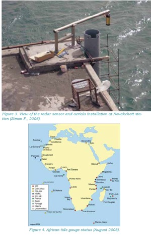
Until 1999, there were only four African operational measuring stations supplying data to the Global Sea-Level Observing System (GLOSS). Today, GLOSS has 290 stations that monitor changes in sea level at both regional and global levels. Thanks to ODINAFRICA, Africa now figures prominently on GLOSS’s world map. A Pan-African coastal observing system has also been developed, based on a network of 50 tide gauges. The ODINAFRICA website has also been established.
Another example of ODINAFRICA output is the African Marine Atlas (AMA), an interactive web application allowing several data layers to be viewed in superposition.
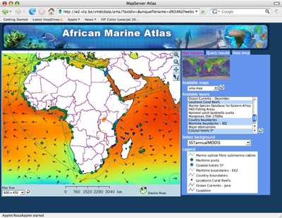
AMA can provide such layered data at both local and continental levels. For example, it shows the location of all measuring points for the Marine Species Database for Eastern Africa: MASDEA was set up with the assistance of the VLIZ and is now a fully-fledged ODINAFRICA activity.
Through this integrated approach, ODINAFRICA is helping to underpin the sustainable protection of Africa’s coastal regions and marine environment. It also fulfils some of the ambitions set out in the marine and coastal resources section of the NEPAD (New Partnership for Africa’s Development) Environment Initiative. Inclusion in NEPAD ensures that all stakeholders have a real say on the marine environment, including the private sector, policymakers and the education sector. With FUST being part of the EWI Science Sharing Programme, Flanders - in collaboration with UNESCO - is making a significant contribution (€1.437 million in 2007) to the development of a sustainable policy for Africa’s coastal regions.